With contributions from Cirencester Archaeological & Historical Society, Cirencester Civic Society, members & friends
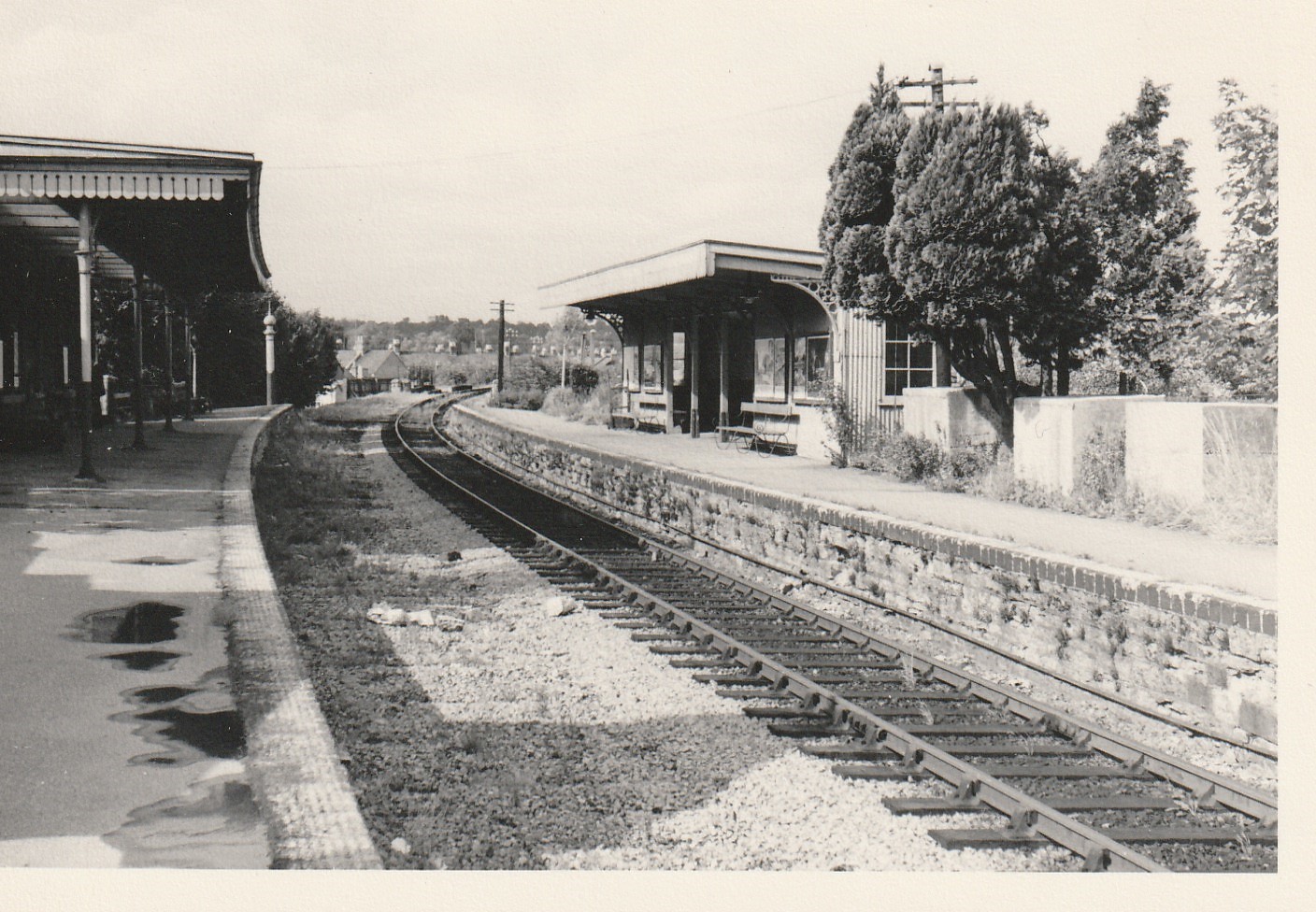
(Picture top: Watermoor station – final days in 1961.)
Cirencester’s Fire Station roundabout in Watermoor is back in use, having been reconfigured to deal with much heavier traffic flows around and onto the ring road than were ever anticipated when first constructed in the 1970s. It remains the nearest link into the south of the town, accessed to and from Watermoor Road, but crucially also into the Love Lane business & commercial area and onward into The Steadings development, Cirencester’s current and major development area.
That’s the present and the future, but what about the past? What was there in this large area before the ring road came? The answer includes the site of Cirencester’s ‘other‘ railway station, on the cross-country north-south Midland & South Western Junction Railway, plus a large sprawl of what was once its railway locomotive works and yards, and to its south the site of Cirencester’s gas works.
Only a few clues of all of that now remain and are not easy to find, not least because the railway alignment was essentially north-south whilst the new road crosses east-west. Obliteration was the order of the day, such was the scale of change, but there are remnants, and the new pedestrian crossings on the roundabout are helpful in the challenge of tracking them down.

Most difficult to get into focus is the truncation of several previous roads across this area. The best clue is looking up what is now Watermoor Way along the line of the original station approach; on the left today ATS and Screwfix, accessed from Mercian Close, sit on the line itself as it approached from the railway bridge over Watermoor Road. Looking the other way, Southgate Mews neatly fills the gap of the line embankment heading north.
Watermoor Station was at the point where the currently vacant Mercian Close units meet the roundabout, then across the ring road itself, where its line to the south is largely obscured by the Guardian Self Store building and the modern alignment of Bridge Road. In places it is a notably tight fit, especially where the nearby Kingsmead housing, a cul-de-sac development of the mid-1930s, was truncated at its northern end to make space for the roundabout approach. Surviving here until the recent works but now sadly reduced in number was a line of large concrete blocks, anti-tank traps aligned alongside the station south-side platform, and always a good clue to the former alignment.

The site of the station access today.
Bridge Road, which had an underpass beneath the railway just south of the station, was truncated for the original Love Lane mini-roundabout, but can still be found in its two sections, linking up on one side with Siddington Road and its rows of housing, and on the other a short stretch now called Bridge End, linking up with Chesterton Lane by what is now Cirencester Baptist Church (the old NAAFI site).
North of Bridge End up to and including the roundabout was filled with ex-railway works, yards and open storage and a long-time eyesore before and certainly once the railway had finally closed in 1964. For years it housed a large scrap yard, which dominated this area in many ways, making its reuse for road development purposes seem both logical and attractive.
The other significant realignment on the 1970s ring road project was the truncation of Chesterton Lane at its Watermoor end, being redirected from the Bridge Road junction into Love Lane and around, leaving access only into Bridge End and the site of the town’s old gas works, more of which in a later issue.
For decades this whole area was a vital provider of employment for Watermoor and beyond, especially once the railway works were fully developed between 1895 and 1924. Nearby associated housing, particularly in School Lane and Midland Road has also vanished, making it difficult today to fully appreciate the scale of what once was there.
At its heart, Cirencester (Watermoor) station has also faded from memory and joined the list of many other truly lost railway stations on this long cross-country route, itself an historical relic once linking Manchester with Southampton and many points in between.
David Viner
A previous article on Watermoor Station appeared in Snapshots, page 37, in the December 2021 issue of Ciren Scene. See
https://digital.magmanager.co.uk/Preview/Index/2492661#page/37
Support Cirencester’s principal heritage societies and their event programmes: Archaeological & Historical Society (www.cirenhistory.org.uk) and Civic Society (www.ccsoc.org.uk), which runs a programme of Town Walks in the season plus pre-booked for small groups. See the Society’s website or email Rob Tuttle: info@townwalkscirencester.uk or robtuttle@btinternet.com
To keep up to date with what´s going on in town, feel free to join our Facebook group by clicking here. To advertise with the magazine check out the Rates & Media Pack – Ciren Scene!
0 comments on “CAHS Snapshots of Local History: Where was Cirencester’s Watermoor station?”